
How It Works
1. Install
Permanent seabed anchor stations are installed within defined coastal monitoring zones. These stations establish fixed locations for buoy deployment while minimizing visible surface infrastructure and enabling consistent, repeatable measurements of local conditions.
2. Monitor
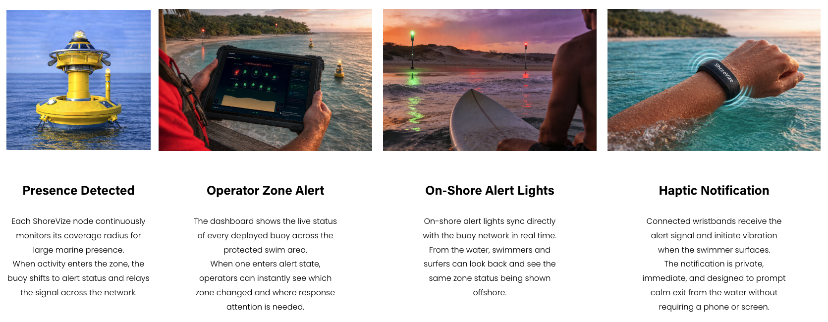
Each buoy operates as an independent detection node secured to its anchor station. Multiple nodes form an offshore and surf‑zone sensing array with overlapping monitoring areas that continuously watch for large marine presence and sample waves and currents associated with rip‑current risk along the protected swim corridor.
3. Alert
In the ShoreVize concept, when a buoy detects large marine presence or elevated surf‑zone risk within its monitoring radius, the event is transmitted to a shore‑based monitoring interface. Lifeguards and coastal operators receive zone‑specific alerts—via dashboard and synchronized shore lights—intended to support rapid, informed decisions about both shark safety and rip‑current conditions.
ShoreVize is currently in concept development. Key questions to be answered during prototyping and testing include:
Which sonar configurations perform most reliably in surf‑zone turbulence and wave clutter
What detection range and false‑alert rates are realistic in real ocean conditions
How integrated wave and current sensors behave in dynamic surf zones, and how well their signals correlate with elevated rip‑current risk in practice
How biofouling affects sensor performance over weeks and months of deployment
What the optimal service interval is for the removable sensor module
Whether the haptic wristband alert is intuitive and useful for different beach user types in real‑world trials
How best to fuse in‑water data with any compatible webcam‑based rip‑detection feeds where those systems are already deployed
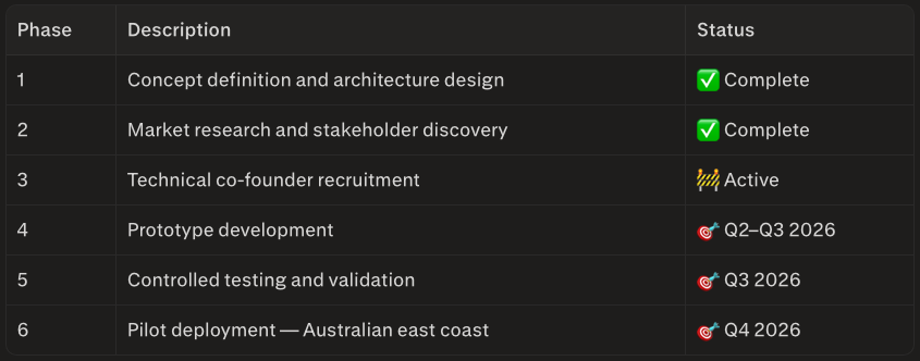
No prototype has been built or field-tested yet. These are the development milestones the concept is being built toward.
Development Roadmap
Distributed Coastal Monitoring Infrastructure
Managed beaches rely on lifeguard patrols, aerial observation, and tag‑based tracking programs to monitor marine wildlife activity—and, separately, on forecasts and visual judgement to gauge rip‑current risk. These methods provide limited and intermittent visibility across the water column and the surf zone, and often detect hazards only after they are already near swimmers.
Most existing tools are reactive. Aircraft patrols occur periodically, tagging programs only track previously tagged animals, and visual observation of rips is constrained by distance, water clarity, and environmental conditions. Model‑based rip forecasts help, but they rarely capture real‑time, beach‑scale changes in waves and currents. As a result, coastal operators frequently face uncertainty when making decisions about swimmer safety.
Precautionary beach closures and delayed response times create operational disruption for municipalities, lifeguards, and coastal tourism operators.
The challenge is not a total lack of information.
The challenge is the absence of continuous, in‑water awareness offshore and in the surf zone.
The ShoreVize Solution
ShoreVize installs fixed seabed anchor stations that support a distributed network of intelligent monitoring buoys positioned offshore and across key surf‑zone segments.
Each buoy operates as an independent detection node within a coordinated coastal array. Together, these nodes are designed to create overlapping monitoring zones that continuously watch for large marine presence and measure local wave and current patterns linked to rip‑current risk across designated swim corridors.
Rather than attempting to classify species or track individual animals, the system focuses on identifying large marine presence within defined areas, characterizing hazardous surf‑zone conditions, and transmitting clear, real‑time alerts and risk indicators to shore. Over time, ShoreVize is also intended to plug into compatible webcam‑based rip‑current AI systems where they already exist, so in‑water data and camera‑derived rip signals can be viewed in a single operational picture.
The design goal is to move coastal safety from reactive response toward proactive situational awareness.