Technology
The architecture described below reflects the current ShoreVize design concept — not a validated, deployed configuration. No prototype has been built or field-tested yet.
Modular Anchor Stations
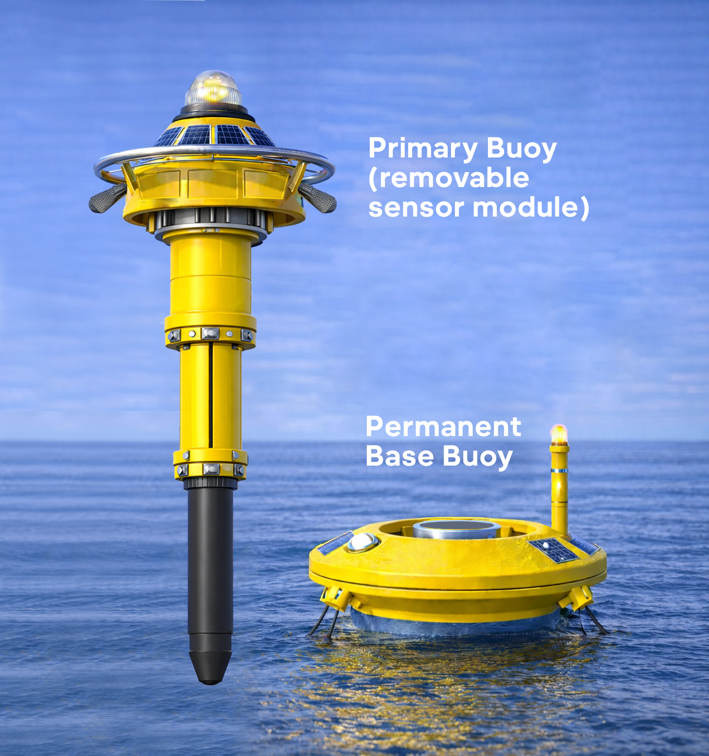
ShoreVize consists of a permanently moored base buoy and a removable sensor buoy. The base buoy remains anchored to the seabed via subsurface bridle mooring and carries a fixed visibility mast with an always‑on navigation light—so the structure stays a compliant marker whether the sensor module is present or not.
The sensor buoy—housing sonar, wave and current sensors, solar panels, and electronics—docks into the base through a quick‑connect interface secured by manually actuated paddle latches. When servicing is needed, operators approach by small boat, release the latches, and lift the sensor buoy using an integrated service ring. A replacement sensor buoy is then docked in its place. The entire process is intended to take minutes and require no divers or anchor retrieval.
Each base buoy defines a fixed monitoring location, with sensor buoys operating as independent nodes within a coordinated mesh network. At each node, the goal is to combine large‑marine‑presence detection with continuous measurements of local waves and currents, so the system can support both shark alerts and rip‑current risk awareness as the platform matures.
Distributed Detection System
ShoreVize buoys are deployed as a coordinated mesh network, with individual nodes spaced at intervals offshore to create overlapping detection zones across the protected swim area. Each node is intended to monitor its coverage radius for large marine presence while also sampling nearshore wave and current patterns that correlate with elevated rip‑current risk.
In the ShoreVize concept, when an outer buoy detects large marine life or hazardous surf‑zone conditions, it immediately relays the alert to inner buoys closer to shore. This cascading notification is designed to give swimmers and lifeguards early warning before a threat or higher‑risk segment reaches the main swim zone.
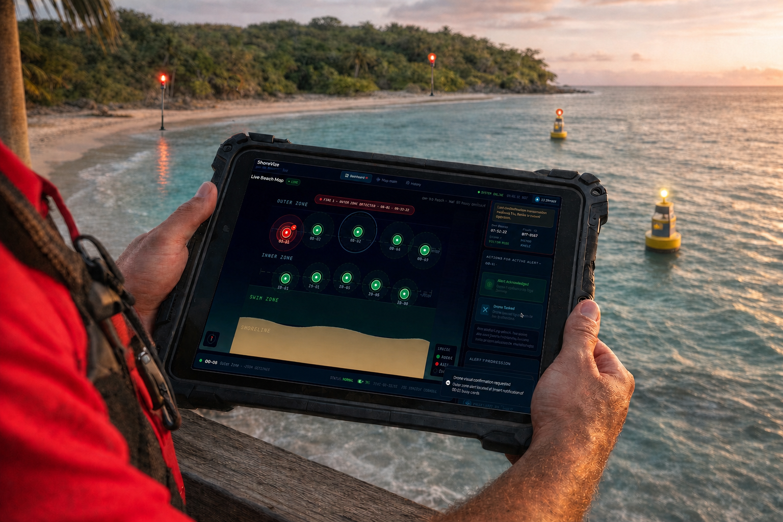
Each alert is meant to be location‑specific. The envisioned lifeguard dashboard would display which buoy triggered, in what order, and with what type of hazard (e.g., marine‑presence alert vs. elevated rip‑risk flag), giving responders a read on where the issue is, how it’s moving, and which swimmers may need priority evacuation. The concept design includes an Acknowledge Alert action and a Request Visual Confirmation option, so operators can dispatch a drone or tap into existing beach‑webcam AI systems for an additional visual check—without leaving the interface.
Note: The dashboard shown is a concept interface. No deployed system exists yet. Detection performance and rip‑risk logic have not been validated offshore.
This two‑action workflow is intended to keep the response loop tight: the lifeguard sees where the detection is, confirms they’re on it, and, when available, layers in visual confirmation—all from the same app.
Coastal Alert & Comms. Network
When a detection occurs, the triggering buoy broadcasts an alert across the mesh network. Every connected buoy relays the message, ensuring the signal reaches shore even from the outermost nodes—and each buoy in the array can light up to reflect alert status in real time.
That same signal is designed to trigger synchronized on‑shore alert lights, which mirror the buoy array. Swimmers and surfers facing the beach are intended to see the same green‑to‑red status change on land that the buoys display offshore—creating a unified visual layer across the entire protected zone, whether the alert is driven by a marine‑presence event or a flagged high‑risk segment in the surf zone.
On shore, the lifeguard dashboard shows a live map of buoy status, alert type, and activation sequence. If an outer buoy raises a shark alert and a mid‑zone buoy flags elevated rip‑current risk, responders immediately understand direction of travel, which segments are more hazardous, and where to focus evacuation or patrols.
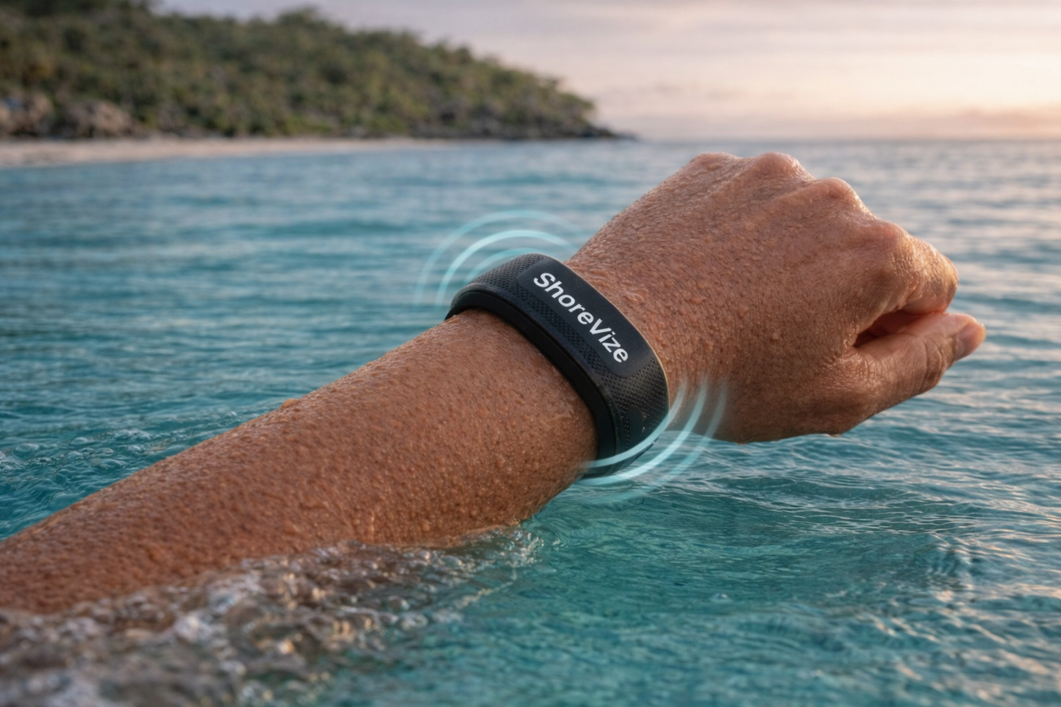
As the platform evolves, ShoreVize is also exploring optional integration with webcam‑based AI rip‑detection systems at beaches that already run them, so both in‑water data and camera‑derived rip indicators can appear in a single operational view. Optional waterproof haptic wristbands remain a future concept: the intent is for connected wearables to translate alert signals into simple vibration patterns, giving individuals a private prompt to look up and head in—without needing a phone or screen.
The result is a multi‑layer communications network—buoy lights, shore lights, lifeguard dashboard, and potential haptic wearables—designed to deliver early warning to everyone in and around the water, exactly when they need it, with minimal noise or confusion.
What ShoreVize Is Not Claiming Yet
A working offshore prototype
Validated detection or rip‑risk performance in the field
A deployed operator dashboard (all dashboard visuals are concept interfaces)
Pilot‑tested wristband behavior or webcam‑AI integration
Commercial‑ready hardware or confirmed pricing
These are the milestones the concept is being built toward. Prototype development is targeted for Q2–Q3 2026, with rip‑current sensing and third‑party AI integrations as follow‑on capabilities rather than first‑release promises.